Blog

  • Ward’s Coppice

    This document was a separate page which I used to report on Ward’s Coppice when work was being done on it. Unfortunately, I dropped the ball on this and the others who were supposed to be helping have also ignored it for many months.

    Originally posted as a private page on 16th August, 2024

    Please click on any image to enlarge it.

    A quick history.

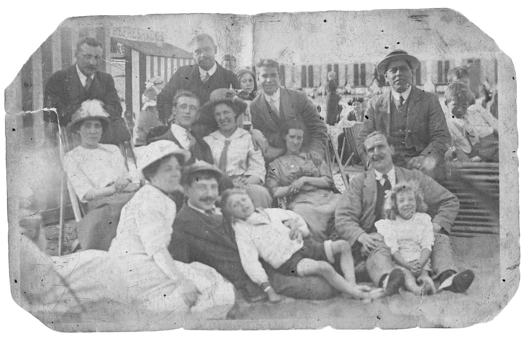
    Back in the ’80s the house on Clive Avenue called Avenhills was owned by a birdwatcher called Mr. Ward. At the back of his property was a woodland where he found Pied Flycatchers and lots of other lovely wild things. He built a hide there, put up nest boxes which were used by the flycatchers, and the woodland became a lovely nature reserve. When he passed away, Mr. Ward left the reserve to the Church Stretton branch of the Shropshire Ornithological Society (SOS).

    Unfortunately, the local branch couldn’t really look after it. Sporadic attempts were made to cut back the encroaching bush, but over time the hide was vandalised, the nest boxes fell apart and the place became unloved and dangerous.

    The local branch isn’t set up to own and maintain property but the main society is, so the decision was made to hand the reserve over to the main branch of the SOS. A lengthy discussion then took place about who might actually take care of it locally. Eventually, it was realised that this woodland could become part of the Stepping Stones project which was set up to make natural wildlife corridors joining the various natural areas in the Stretton Hills. Overtures were made to the National Trust. Inspection visits were arranged, and finally an agreement was made for volunteers from the Trust to help out with the preliminary clean-up of the site.

    The future of this reserve is still uncertain, but first steps have now been made. The Wednesday volunteer group (WAGS) turned up in full force along with rangers Patrick and Dave to do a clean-up. The rest of this page documents the amazing amount of work they have done (though doesn’t actually dwell on the amount of cake that was consumed!).

    Today’s Visit

    Approachng the site, up Kenyon Road (a green lane or track), one can immediately see that the entrance gates have been cleared. What had once been a jungle of bracken, bramble and nettles was now a welcome clearing.

    Avenhills is to the left – it is now the residence of one of the National Trust Volunteers who turned out to help clear the site.

    The gate area seems quite complicated. I’ve never actually seen it before without it’s enveloping weeds! There is a large gate which has been padlocked – who knows who has the key? John thinks the Woodland Trust put in this gate for access to their land which surrounds the reserve, but if they did, they can’t possibly take vehicles through as their wedge gets narrower and narrower as it goes along the edge of the reserve.

    To the right of the vehicle entrance is a kissing gate which has a notice about the reserve being the property of the SOS. The uprights are loose and the whole thing is falling down. Mike (next door neighbour) tied it up with string to keep it upright, so the reserve isn’t accessible at the moment. To get in I had to crawl under the horizontal beams.

    Further to the right is a bank and ditch along the track (Kenyon Road). Along the top of the bank was a fence which is now lying down. It was brought down over the years by the weight of the bracken lying on top of it. You could just walk into the reserve if you climb up the bank there.

    Moving on into the reserve, I climbed the steps. I was delighted to find that they had been cleared and the railing had been stabilised to supply sturdy support. The WAGS really worked hard to make the area safe and accessible.

    The next surprise was the hide itself. The WAGS had cleaned up! No more broken glass, no more empty beer cans and discarded trash – the whole place was pristine and tidy, both outside and in!

    The structure has problems which need to be addressed. There is quite a bit of rotten wood, especially along the bottom of the building. All of the glass windows are gone, too, but basically it is as I first saw it 18 years ago.

    Around the reserve any brash and branches that have had to be cut have been tidily arranged in habitat piles. There’s still plenty of dead wood about along with lots of undergrowth, saplings and shrubs so there’s plenty of cover for wild things in this reserve. Today I noticed a massive oak tree – what a lovely old thing it is! I bet there are thousands of different species sheltering under its leaves, burrowing in its bark and living on its branches.

    Although the pied flycatcher boxes have disappeared, there are a couple of dormouse boxes. Mike told me that one had sprung open but actually had a moss cup in it – wonder who was living in there? The WAGS closed them up, but they need to be inspected, possibly cleaned and made safe for potential residents.

    I was able to walk around most of the fence line. It appears to be standing most of the way around although several of the posts are quite loose, and will need to be replaced. In one spot where a large branch had fallen across the fence it has been squashed to the ground and the posts have been destroyed. Apparently some dog-walkers and possibly other people exploring the surrounding Gough’s coppice have trampled over this part of the fence to enter the reserve. I suspect this is how most of the people who trashed the hide got in. Now that the overlying wood has been removed, we need to replace the posts and reinstate the fence as rapidly as possible.

    On the north-east side of the property the boundary line becomes less distinct. The pig-wire fence is replaced with a few strands of single wire and these disappear into the undergrowth.

    Mike is interested to find out more about the boundaries in this area. He is not certain where his property ends and where ours (and/or the Woodland Trust’s) begins. It would probably be a good idea to sort this out with him, if that were possible. Somehow, I doubt we will get much feedback from the Woodland Trust. Here is a copy of the plot map from the Land Registry. Click on it to bring it up on a separate page and then click again to enlarge it.

  • My English Grandparents

    Alfred Thomas Marlborough – My paternal Grandfather

    Alfred Thomas Marlborough was born on December 29, 1879, to Henry Marlborough and Sarah Eliza Marlborough/Ashby of 37 Ironmonger Street.  He was baptised at St. Lukes Finsbury, on May 7, 1880.  Henry is listed as a labourer in the baptismal record.

    In the 1881 census, the 2 year old Alfred T. is living with his parents and siblings at 38 Ironmonger Street.  Henry’s occupation is labourer and Alfred’s older siblings are listed as scholars, except his eldest brother William J (15) who does not have an occupation listed.

    I think these are 4 of the 7 Marlborough brothers. Alfred Thomas is at the left.

    In 1891 he is part of a very large family living at 37 Ironmonger Street.  The family are:

    • Henry Marlborough – 48 (father),
    • Sarah E Marlborough – 46 (mother),
    • Edward G Marlborough – 21,
    • Harry J Marlborough – 18,
    • Louisa E Marlborough – 15,
    • Annie E Marlborough – 13,
    • Alfred T Marlborough – 11,
    • Florence A Marlborough – 9,
    • Albert F Marlborough – 7,
    • Walter C Marlborough – 5. 

    Henry is now listed as a warehouse man, as is Edward G.  Harry is a packing case maker and Louisa is a pupil teacher.  All the others are listed as scholars (i.e. in school).  William is no longer living with the family at the age of 25.

    Ironmonger Street no longer exists.  We can see it on the 1869 map, but it is now in the middle of an open space and no trace appears. It would have run across the present Radnor Park from the middle entrance to St Lukes Garden behind Bartholomew Square to Lizard Street. 

    Click twice on the maps below to get an expanded view.

    On Booth’s Poverty map of London from the late 1890s this street is shown in PINK: Fairly comfortable. Good ordinary earnings.

    In 1901 most of the family are still together, although Harry has left and the family is now living at 5 Elmore Street.  Family member’s jobs are listed as:  Henry and Edward G are oil and colour warehousemen;  Louisa and Florence are teachers; Annie is a dressmaker; Alfred T is a labourer in a sundries warehouse; Albert F is an engineering draughtsman and Walter C is an office lad.

    In 1911 the family are still mostly together.  Henry has died and Sarah is now the head of the household and listed as a widow.  They are living at 2 Digby Road, Stoke Newington.  Edward is now a Labourer (colourman), Louisa an assistant teacher with the London County Council, Annie appears to be unemployed, Alfred Thomas is a loading porter at a distillery (Buchanan’s who made Black and White whiskey), Albert is an engineering draughtsman and Walter is now a Furrier’s Clerk.

    Digby Road is now called Digby Crescent.

    Jane Maria Brittain – My paternal Grandmother

    Jane Maria was born on June 5th, 1879, in Islington, to Samuel Brittain and Martha Brittain/Brown.  Martha must have registered the birth.  She made her mark as a cross so she couldn’t write which explains why Jane was registered as Jane Brittan.  The copy of her birth certificate that I have was produced for Jane to go to school.

    Jane was baptised on June 22.  Her parents were listed as Samuel and Martha Brittan of St. Philip St. and Samuel was registered as a milkman.  It’s not clear where the baptism took place, but most likely it was St Philips.

    The 1881 Census shows her living at 2 St Philip St, Islington, with her parents and two month old sister Martha. St Philip St is now St Philip’s Way.  On Booth’s Poverty map of London from the late 1890s this street is shown in PURPLE: Mixed. Some comfortable others poor. 

    On 15/11/1886 Jane was admitted to Angler’s Gardens School. This school was located in a very rundown street and Angler’s Gardens itself was demolished in 1877.  It ran off Popham Road towards Lower Road, but didn’t go through.  The entry in the school register indicates that the family were now living at 45 Popham Road, Islington.  Granny had come up from Angler’s Gardens Infants school where she had spent 3.5 years  She continued to Standard 5 which she entered in 1890.  By then, the school was called Popham Road School.  It is now called Charles Lamb School.  She left on 26/12/1891 aged 12.  I think she continued with school till she was 14, but I’m not sure.  Her sister and brother (Martha and Edward) also attended the same school.

    In 1891, the family were still living at 45 Popham Road.  Samuel Brittain is listed in the census as a labourer.  In 1901 the whole family is still in the same house, but Samuel Brittain works as a “drug grinder”, Jane and sister Martha are both “box makers – cardboard” and Edward is a “tailors cutter”.  In 1911, they are still all in the same place and doing the same jobs.  On Booth’s Poverty map of London from the late 1890s this street is also shown in PURPLE: Mixed. Some comfortable others poor.

    Beach Party in the Early 1900s – Jane and Alfred are on the left of the photo

    Jane Marlborough/Brittain and Alfred Thomas Marlborogh Married Life

    Jane Maria Brittain married Alfred Thomas Marlborough on March 30, 1918 at St Philip the Evangelist Church in Islington.  Jane’s father, Samuel was listed as a Railway Porter, while Alfred’s father, Harry was listed as a (deceased) Oil and Colourman.  Jane was living at 8 Canon St and Alfred at 8 Mattison Road, Harringay.

    The electoral record for 1918 shows Jane and Alfred Marlborough living at 73 Arlington St.

    On June 8, 1919 their son, Alfred Edward Marlborough was born.

    In 1922 through 1939 the electoral rolls show that Jane and Alfred Thomas Marlborough remained at 73 Arlington Street (now called Arlington Avenue).  Also living in the same house through the period were their very good friends Alice and Alfred Lys.  The area near their house was hit 4 times by high incendiary bombs during the Blitz and there could have been other bombs later in the war.  I’m not sure how long they stayed in the house, although my mother said they were still there in 1944.

    Jane Brittain Marlborough and Alfred Thomas Marlborough in the early 1940s

    I have no electoral roll evidence of residence for Jane or Alfred Thomas during WWII.  However, in 1945 Alfred Edward was listed at 41 Ecclesbourne Road.  Where were his wife and parents?  It looks as though he stayed there for a few months, then Jane and Alfred Thomas took over when he moved to Elmore St.

    In 1946, Jane and Alfred Thomas are listed at 41 Ecclesbourne Road along with Nathanial G. Turnell.  This is “Uncle George”, Jane’s brother-in-law and widower of her sister Martha who died in 1945. 

    Alfred Thomas died in 1947.  He was buried on November 19, 1947 in Islington Cemetery which is located in East Finchley. George Turnell died in 1949. 

    In 1950/51 Jane moved to 57 Ockendon Road to live with us.  In 1959 the whole family moved to Stanmore where Jane continued to live with us till her death in 1967 at the age of 86.  Jane is buried in Harrow Weald Cemetery.

  • Snow

    This is the view from my workroom. The snow started early this morning and it has been snowing on and off since then. We’re expecting it to last through the evening. The treed area on the left belongs to a couple of our next-door neighbours and the newly built garage on the right belongs to others. Our land actually adjoins 8 other properties.

    Our driveway is very steep – it gets steeper as you climb up to the road. This is why we have a 4-wheel drive vehicle. We can get up it, but I’m not sure about the neighbours on the right, or the people working on the garage. I think there’s some snow shovelling in our future!

  • Two Seasons of Pictures

    Early Summer 2020
    Early Autumn 2020